Northern Ireland: 26 district council areas
district council areas: Antrim, Ards, Armagh, Ballymena, Ballymoney, Banbridge, Belfast, Carrickfergus, Castlereagh, Coleraine, Cookstown, Craigavon, Derry, Down, Dungannon, Fermanagh, Larne, Limavady, Lisburn, Magherafelt, Moyle, Newry and Mourne, Newtownabbey, North Down, Omagh, Strabane
Scotland: 32 council areas
council areas: Aberdeen City, Aberdeenshire, Angus, Argyll and Bute, Clackmannanshire, Dumfries and Galloway, Dundee City, East Ayrshire, East Dunbartonshire, East Lothian, East Renfrewshire, City of Edinburgh, Eilean Siar (Western Isles), Falkirk, Fife, Glasgow City, Highland, Inverclyde, Midlothian, Moray, North Ayrshire, North Lanarkshire, Orkney Islands, Perth and Kinross, Renfrewshire, Shetland Islands, South Ayrshire, South Lanarkshire, Stirling, The Scottish Borders, West Dunbartonshire, West Lothian
Wales: 22 unitary authorities
unitary authorities: Blaenau Gwent; Bridgend; Caerphilly; Cardiff; Carmarthenshire; Ceredigion; Conwy; Denbighshire; Flintshire; Gwynedd; Isle of Anglesey; Merthyr Tydfil; Monmouthshire; Neath Port Talbot; Newport; Pembrokeshire; Powys; Rhondda Cynon Taff; Swansea; The Vale of Glamorgan; Torfaen; Wrexham
Leaders: H.M. Queen Elizabeth II; Prime Minister David Cameron
Sources: CIA World Fact Book, Encyclopaedia Britannica,
GDP Official Exchange Rate (OER is more precise at gauging a countries economic power)
(Estimated 2011): $2.481 (US$) or (GBP)
GDP (OER) Per Capita (per member of the population estimated 2011): (US$) or (GBP)
GDP Purchasing Power Parity (PPP is good for gauging living conditions and use of resources but not as accurate as OER. This data has been calculated based on the sum value of all goods and services produced in the country valued at prices prevailing in the United States)
(Estimated 2011): $2.25 trillion (US$) or (GBP)
GDP (PPP) Per Capita (per member of the population estimated 2011): $36,600 (US$) or (GBP)
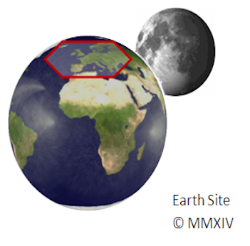
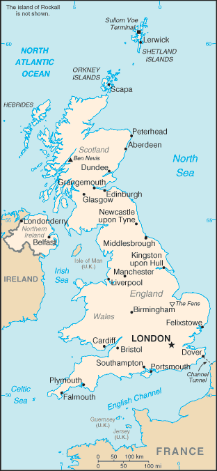
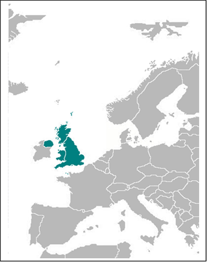
Capital: London
Population (Estimated July 2012): 63,047,162
Area: 243,073km2 or 93,851mi2
Currency: Pound Sterling (£)
Official Language: English
Political Information: Constitutional Monarchy with Democratic Parliament
Official Religion: No Official Religion (approximately 71.6% of the population is Christian, 23.1% have unspecified or no religious beliefs, 2.7% are Muslim, 1% are Hindu and a small minority are Jedi)
Highest Mountain: Ben Nevis (in Scotland) at 1,344m or 4,377ft
Largest River:
Time Zone (GMT/UTC): GMT
Wildlife:
Counties/Provinces/States: England: 27 two-tier counties, 32 London boroughs and 1 City of London or Greater London, 36 metropolitan districts, 56 unitary authorities (including 4 single-tier counties*)
two-tier counties: Buckinghamshire, Cambridgeshire, Cumbria, Derbyshire, Devon, Dorset, East Sussex, Essex, Gloucestershire, Hampshire, Hertfordshire, Kent, Lancashire, Leicestershire, Lincolnshire, Norfolk, North Yorkshire, Northamptonshire, Nottinghamshire, Oxfordshire, Somerset, Staffordshire, Suffolk, Surrey, Warwickshire, West Sussex, Worcestershire
London boroughs and City of London or Greater London: Barking and Dagenham, Barnet, Bexley, Brent, Bromley, Camden, Croydon, Ealing, Enfield, Greenwich, Hackney, Hammersmith and Fulham, Haringey, Harrow, Havering, Hillingdon, Hounslow, Islington, Kensington and Chelsea, Kingston upon Thames, Lambeth, Lewisham, City of London, Merton, Newham, Redbridge, Richmond upon Thames, Southwark, Sutton, Tower Hamlets, Waltham Forest, Wandsworth, Westminster
metropolitan districts: Barnsley, Birmingham, Bolton, Bradford, Bury, Calderdale, Coventry, Doncaster, Dudley, Gateshead, Kirklees, Knowlsey, Leeds, Liverpool, Manchester, Newcastle upon Tyne, North Tyneside, Oldham, Rochdale, Rotherham, Salford, Sandwell, Sefton, Sheffield, Solihull, South Tyneside, St. Helens, Stockport, Sunderland, Tameside, Trafford, Wakefield, Walsall, Wigan, Wirral, Wolverhampton
unitary authorities: Bath and North East Somerset, Blackburn with Darwen, Bedford, Blackpool, Bournemouth, Bracknell Forest, Brighton and Hove, City of Bristol, Central Bedfordshire, Cheshire East, Cheshire West and Chester, Cornwall, Darlington, Derby, Durham County*, East Riding of Yorkshire, Halton, Hartlepool, Herefordshire*, Isle of Wight*, Isles of Scilly*, City of Kingston upon Hull, Leicester, Luton, Medway, Middlesbrough, Milton Keynes, North East Lincolnshire, North Lincolnshire, North Somerset, Northumberland*, Nottingham, Peterborough, Plymouth, Poole, Portsmouth, Reading, Redcar and Cleveland, Rutland, Shropshire, Slough, South Gloucestershire, Southampton, Southend-on-Sea, Stockton-on-Tees, Stoke-on-Trent, Swindon, Telford and Wrekin, Thurrock, Torbay, Warrington, West Berkshire, Wiltshire, Windsor and Maidenhead, Wokingham, York


United Kingdom (United Kingdom of Great Britain and Northern Ireland)